
There are seven new different wonders of the world.These are selected according to the people votes.People selected them by votes and then they named as 7 wonders of the world.The new 7 wonders are:
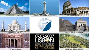

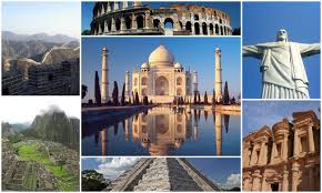
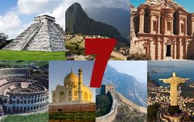
There are seven new different wonders of the world.These are selected according to the people votes.People selected them by votes and then they named as 7 wonders of the world.The new 7 wonders are:
The locations of the seven wonders of the world are;
1.Chichen Itza:
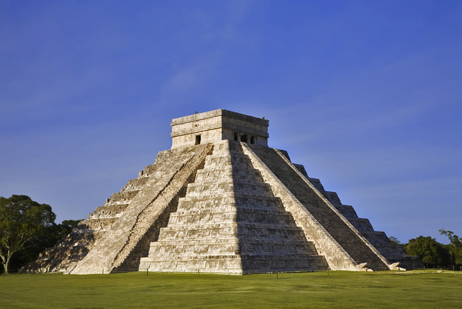
It is located in Mexico.
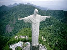
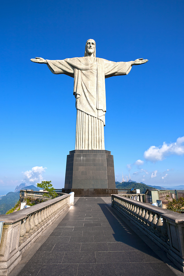
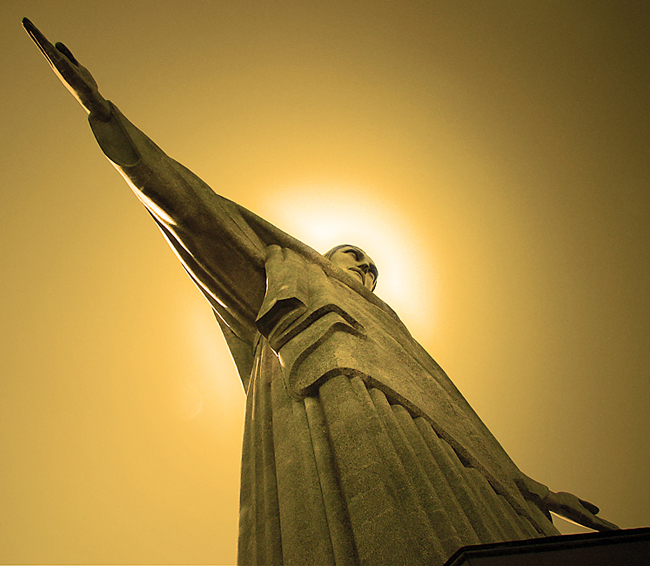
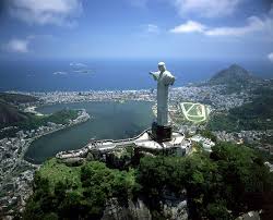
2.Christ Redeemer:
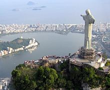
It is located in Brazil.
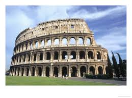
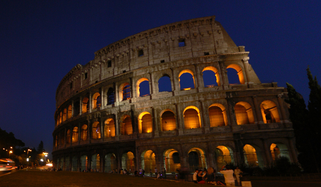
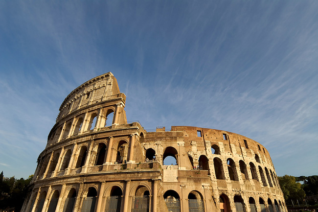
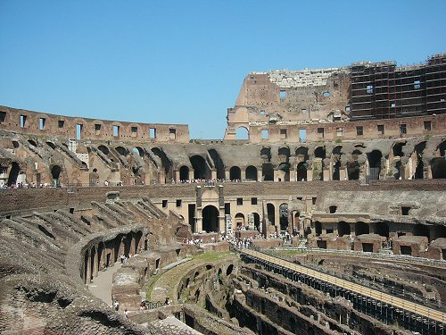
3.Roman Colosseum:

It is located in Italy.
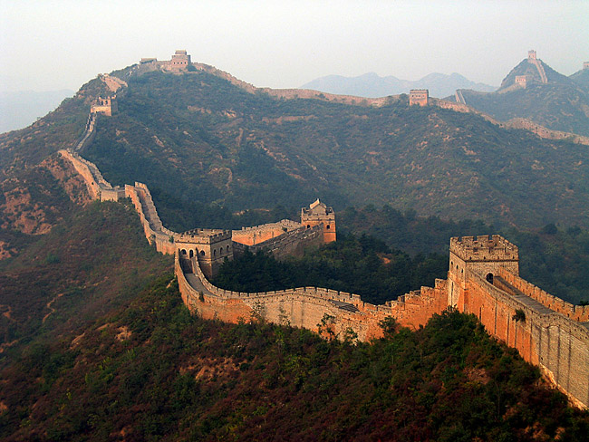
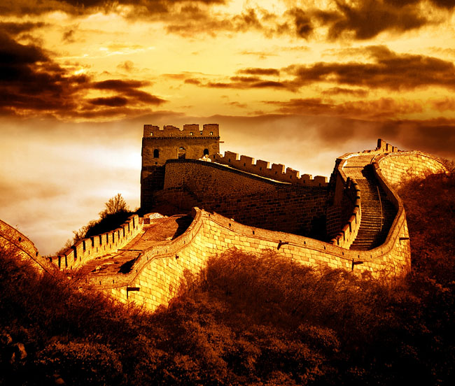
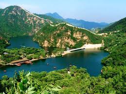
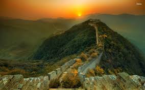
4.The Great wall of China:
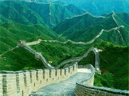
It is located in China.
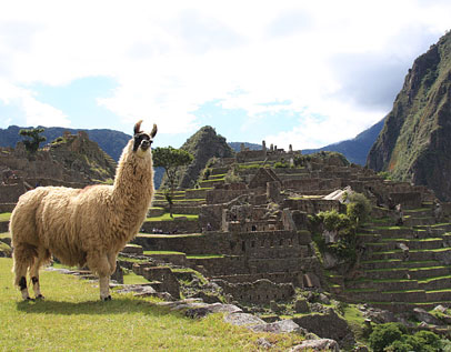
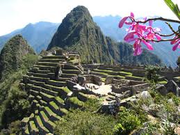
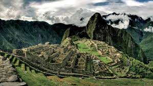
5.Machu Pecchu:
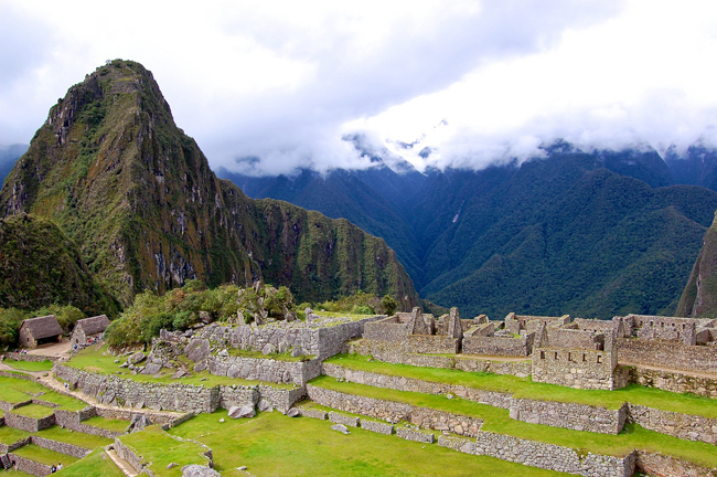
It is located in Perue.
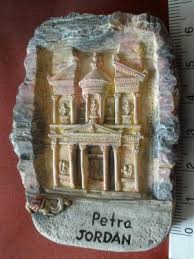
6.Petra:

It is located in Jordan.
7.The Taj Mahal:
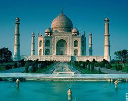
It is located in Agra, a city of India.
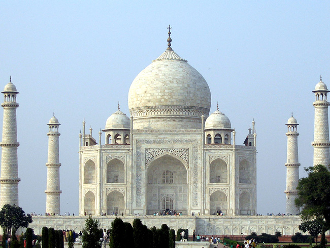
The Taj Mahal of Agra, on the banks of the River Yamuna, conjures up appreciation for its beauty. The construction was a result of love. Mughal Emperor Shah Jahan dedicated the monument in memory of his wife Mumtaz Mahal. It’s said he fell in love with her at first sight. Translated “Crown Palace,” the wonder is of pure white marble, with exquisite ornamentation, gemstones, and beautiful surroundings.The origin of the name “Taj Mahal” is not clear. Court histories from Shah Jehan’s reign only call it the rauza (tomb) of Mumtaz Mahal. It is generally believed that “Taj Mahal” (usually translated as either “Crown Palace” or “Crown of the Palace”) is an abbreviated version of her name, Mumtaz Mahal.
The construction of this marble masterpiece is credited to the Mughal emperor Shah Jahan who erected this mausoleum in the memory of his beloved wife, Arjumand Bano Begum, popularly known as Mumtaz Mahal, who died in AH 1040 (AD 1630). Her last wish to her husband was “to build a tomb in her memory such as the world had never seen before”. Thus emperor Shah Jahan set about building this fairytale like marvel. The construction of Taj Mahal was started in AD 1631 and completed at the end of 1648 AD. For seventeen years, twenty thousand workmen are said to be employed on it daily, for their accommodation a small town, named after the deceased empress-‘Mumtazabad, now known as Taj Ganj, was built adjacent to it.

Amanat Khan Shirazi was the calligrapher of Taj Mahal, his name occurs at the end of an inscription on one of the gates of the Taj. Poet Ghyasuddin had designed the verses on the tombstone, while Ismail Khan Afridi of Turkey was the dome maker. Muhammad Hanif was the superintendent of Masons. The designer of Taj Mahal was Ustad Ahmad Lahauri. The material was brought in from all over India and central Asia and it took a fleet of 1000 elephants to transport it to the site. The central dome is 187 feet high at the centre. Red sandstone was brought from Fatehpur Sikri, Jasper from Punjab, Jade and Crystal from China, Turquoise from Tibet, Lapis Lazuli and Sapphire from Sri Lanka, Coal and Cornelian from Arabia and diamonds from Panna. In all 28 kind of rare, semi precious and precious stones were used for inlay work in the Taj Mahal. The chief building material, the white marble was brought from the quarries of Makrana, in distt. Nagaur, Rajasthan.
Along with the labourers flocking to Agra, materials for construction also began arriving : principally red sandstone from local quarries and marble dug from the hills of far-off Makrana, slightly southwest of Jaipur in Rajasthan. Although the treasury was well filled, such prodigious quantities of rare stuffs were required that caravans travelled to all corners of the empire and beyond in search of precious materials. From Chinese Turkestan in Central Asia came Nephrite jade and crystal; from Tibet, turquoise; from upper Burma, yellow amber; from Ba
dakhshan in the high mountains of northeastern Afghanistan, lapis lazuli; from Egypt, chrysolite; from the Indian Ocean, rare shells, coral, and mother-of-pearl. Topazes, onyxes, garnets, sapphires, bloodstone, forty three types of gems in all – ranging in depth from Himalayan quartz to Golconda diamonds – were ultimately to be used in embellishing the Taj Mahal.
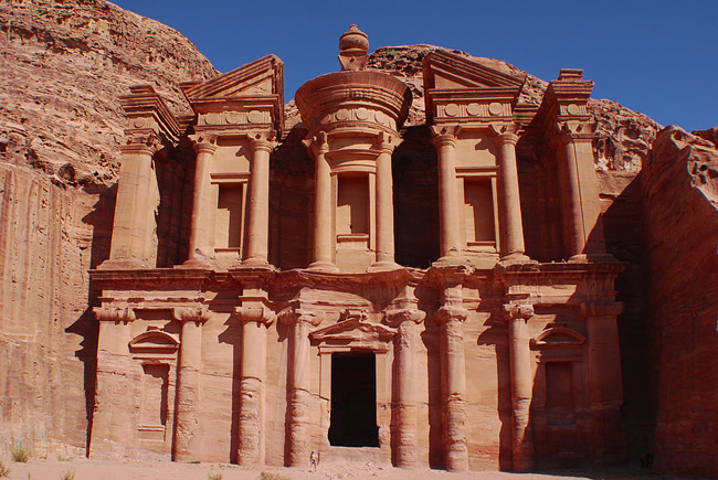
The rosy red mountains and mausoleums are one of the greatest wonders. No doubt Jordan’s greatest tourist attraction is a vast, unique city, carved into a sheer rock face. The Nabataens, an industrious Arab people settled there more than two millennia ago. Enter the city through a long narrow gorge flanked by high cliffs. The tomb of the king extols the engineering genius of the ancient people.With Nabataean rule, Petra became the center for a spice trade that extended from Arabia to Aqaba and Petra, and onward either to Gaza in the northwest, or to the north through Amman to Bostra, Damascus, and finally on to Palmyra and the Syrian Desert. Nabataean Classical monuments reflect the international character of the Nabataean economy through their combination of native tradition and the classical spirit.
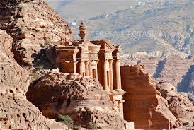
Petra (from the Latin word ‘petrae’, meaning ‘rock’) lies in a great rift valley east of Wadi ‘Araba in Jordan about 80 kilometers south of the Dead Sea. It came into prominence in the late first century BCE (BC) through the success of the spice trade. The city was the principal city of ancient Nabataea and was famous above all for two things: its trade and its hydraulic engineering systems. It was locally autonomous until the reign of Trajan, but it flourished under Roman rule. The town grew up around its Colonnaded Street in the first century CE (AD) and by the mid-first century had witnessed rapid urbanization. Following the flow of the Wadi Musa, the city-center was laid out on either sides of the Colonnaded Street on an elongated plan between the theater in the east and the Qasr al-Bint in the west. The quarries were probably opened in this period, and there followed virtually continuous building through the first and second centuries CE.
The next chapter of history belongs to the Persian period, and it is posited that during this time the Nabataeans migrated into Edom, forcing the Edomites to move into southern Palestine. But little is known about Petra proper until about 312 BC by which time the Nabataeans, one of many Arab tribes, occupied it and made it the capital of their kingdom. At this time, during the Hellenistic rule of the Seleucids, and later, the Ptolemies, the whole area flourished with increased trade and the establishment of new towns such as Philadelphia (Rabbath ‘Ammon, modern Amman) and Gerasa (modern Jerash). Infighting between the Seleucids and Ptolemies allowed the Nabataeans to gain control over the caravan routes between Arabia and Syria. Although there were struggles between the Jewish Maccabeans and the Seleucid overlords, Nabataean trade continued.
According to tradition, in ca. 1200 BCE, the Petra area (but not necessarily the site itself) was populated by Edomites and the area was known as Edom (“red”). Before the Israelite incursions, the Edomites controlled the trade routes from Arabia in the south to Damascus in the north. Little is known about the Edomites at Petra itself, but as a people they were known for their wisdom, their writing, their textile industry, the excellence and fineness of their ceramics, and their skilled metal working.But among the most remarkable of all Nabataean achievements is the hydraulic engineering systems they developed including water conservationsystems and the dams that were constructed to divert the rush of swollen winter waters that create flash floods.
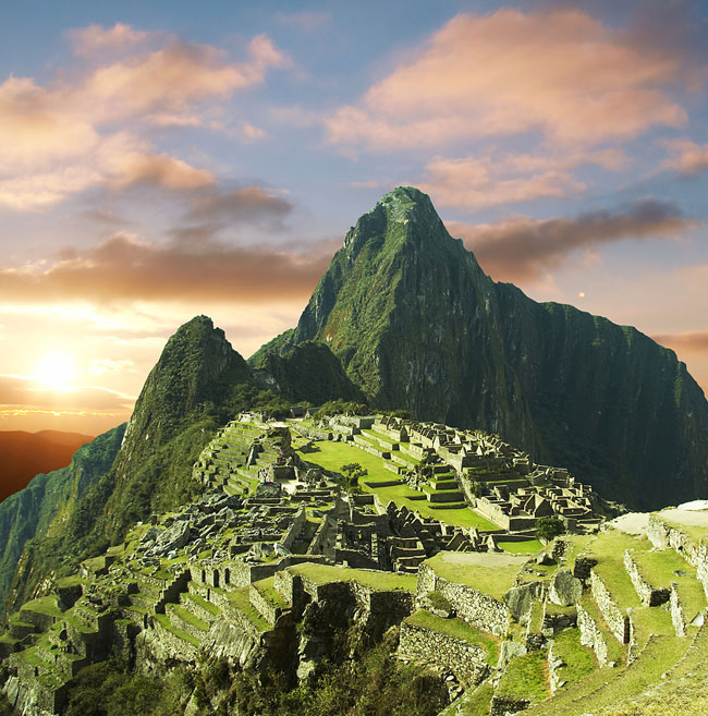
Machu Picchu or Old Peak and Hoaynawhich, New Peak, overlooks the Urabumba River Canyon. About 43 miles from Cuzco, capital of the Incan Civilization, is the home of legends. In July 1911 Martain Bingham, with a topographer, biographer, and geology engineers found Machu Picchu. To this day the stones are fit together so tightly you’d have a hard time getting even a thin knife between them.The history of Machu Picchu is complex and fascinating, and before you arrive at the Lost City of the Incas, you might be interested in learning about it. This site is not only an impressive remnant of the Inca civilization; it is also one of the world’s most important archeological sites. It should come as no surprise how many travelers plan hiking tours to reach the lost city, but how many of them know what they’re looking at? A little background can go a long way to enhancing your visit to Machu Picchu.
An American professor named Hiram Bingham found the site despite the fact that the Incans did a thorough job at keeping secret the lost city, which is located nearly 8,000 feet above sea level. Once this discovery occurred, a wealth of information about the history of Machu Picchu was uncovered. There were 135 skeletons that were found at the site, and more than 100 were women.
Archaeologists have speculated that Machu Picchu was a temple or sanctuary for high priests and women who have been referred to as Virgins of the Sun, though more recent research hasconvinced many that it was built as an estate for the Incan emperor Pachacuti, who ruled from 1438 until 1471 or 1472.There are many intriguing aspects of the history of Machu Picchu, with one of the most fascinating being the relatively small period of its use.
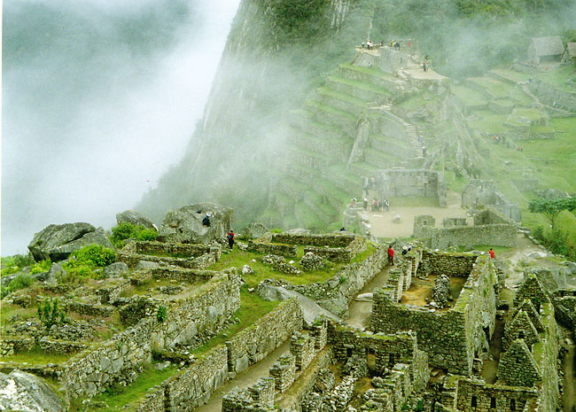
This intricate and beautiful complex was built at the height of the Inca Empire, but it was in use for less than 100 years-around the time of the Spanish conquest of Peru, in the early sixteenth century, Machu Picchu was abandoned. After its rediscovery, it was named a UNESCO World HeritageSite in 1983, and the visitors have not stopped arriving since, as the iconic peaks of Machu Picchu are among the most dazzling archaeological sites worldwide. Archaeologists have divided all the sections of the site into three categories: religious, agricultural, and urban.
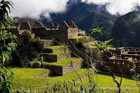
Another interesting historical fact that perhaps saved important details about the Inca civilization is the fact that the Spanish conquerors never found Machu Picchu. While the Spanish were responsible for plundering many other Incan sites, this most sacred site remained a secret. Over the course of centuries, much of the site became overgrown.While it was known by thelocal people, it wasn’t discovered for the rest of the world until 1911 when an 11-year-old boy led Professor Bingham to the site.
The Great Wall of China (220 B.C and 1368 – 1644 A.D.) China Parts of the Great Wall date to more than 2500 years ago. Originally constructed to protect their territories from invasion, Emperor Qin Shi-huang ordered General Meng Tian to extend and connect the walls after 220 BC to dissuade the Huns. The Wall once served as a united defense system, but its functionality and purpose changed over time. No one can deny, however, its greatness. Thousands of people dedicated their lives to building and defending the historic wall.
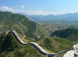
The history of the Great Wall is said to start from the Spring and Autumn Periods when seven powerful states appeared at the same time. In order to defend themselves, they all built walls and stationed troops on the borders. At that time, the total length of the wall had already reached 3,107 miles, belonging to different states.In 221 BC, the Emperor Qin absorbed the other six states and set up the first unified kingdom in Chinese history. In order to strengthen his newly born authority and defend the Huns in the north, he ordered connecting the walls once built by the other states as well as adding some sections of his own. Thus was formed the long Qin’s Great Wall which started from the east of today’s Liaoning Province and ended at Lintao, Gansu Province.
In the Western Han Dynasty, the Huns became more powerful. The Han court started to build more walls on a larger scale in order to consolidate the frontier. In the west, the wall along the Hexi corridor, Yumenguan Pass, and Yangguan Pass was built. In the north, Yanmenguan Pass and Niangziguan Pass in Shanxi were set up. Many more sections of the wall extended to Yinshan Mountain and half of the ancientSilk Road was along the Han’s wall.The Northern Wei, Northern Qi and Northern Zhou Dynasties all built their own sections but on a smaller scale than the walls in the Han Dynasty. The powerful Tang Dynasty saw peace between the northern tribes and central China most of the time, so few wall sections were built in this period.
The Ming Dynasty is the peak of wall building in Chinese history. The Ming suffered a lot by disturbances from minority tribes such as the Dadan, Tufan and Nuzhen. The Ming court from its first emperor to the last ceaselessly built walls in the north. The main line started from Jiuliancheng near the Yalu River in the east to the Jiayuguan Pass in the west and measured over 4,600 miles. Besides adding many more miles of its own, the Ming emperors ordered enlargement of the walls of previous dynasties into double-line or multi-line walls. For example, out of Yanmenguan Pass were added three big stone walls and 23 small ones. Eleven Garrisons were distributed along the main line of the wall. The countless walls, fortresses, and watch towers made the country strongly fortified. In the early Qing Dynasty, some sections of the walls were repaired and several sections were extended. This great engineering work stopped in the middle of the Qing Dynasty.
Owing to its long history, natural disasters and human activities, many sections of the Great Wall are severely damaged and disappearing. Being a world-famous engineering project and witness to the rise and fall of Chinese history, the wall, needs us to take immediate action to protect it!At present, the Great Wall has already lost its military function, and many sections have been repaired and opened to the public. Among them, Badaling is the most famous which receives the most visitors from home and abroad. Mutianyu is famous for its spectacular scenery, Jinshanling and Simatai are well known for the wildness and cragginess, and Jiankou is attracted by its dangerous location. Due to these varieties, it’s no wonder that Great Wall is the most welcomed scenic sightChina.
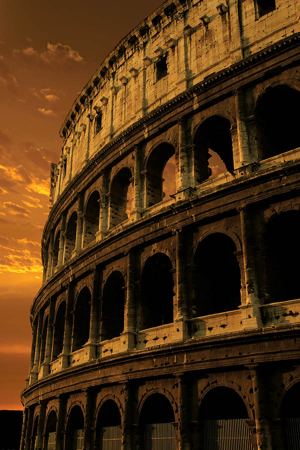
The Roman Colosseum, also spelled, ““Coliseum,” was constructed as an amphitheater. The architect of the masonry and cut stone tiers of arches and half-columns of Doric, Ionic, and Corinthian orders is unknown. The Colosseum could hold 50,000 spectators and had 80 entrances. The base of the building covers six acres and is roughly the height of a 12-15 story building.
The suicide of emperor Nero, in 68, was followed by eighteen months of civil war, the first Roman civil war since Mark Antony’s death in 30 BC. During this period, Rome witnessed the successive rise and fall of three emperors until the final accession of Vespasian, first ruler of the Flavian Dynasty.The first task of the new Emperor Vespasian was to rebuild Rome after the civil war, to stamp his own identity on the city and to wipe away the memory of Nero. He rebuilt the Temple of Jupiter and constructed a vast new Temple of Peace. The Roman Colosseum was to become the showpiece of the new Flavian dynasty of Vespasian and his sons Titus and Domitian.
Vespasian’s decision to build the Colosseum on the site of Nero’s lake can be seen as a gesture of returning a part of the city to the people which emperor Nero had appropriated for his own use. Ironically, the modern name for Vespasian’s great amphitheater is one that makes it more of a memorial to Nero than to the dynasty that replaced him. The word Colosseum is derived from the colossal statue of Nero (the Colossus) that stood nearby, commissioned by him for his Golden House.
Vespasian did not live to see his amphitheater completed. After he died in 79, his oldest son Titus continued construction on the Colosseum. Titus opened it to the public in AD 80. During the dedication of the Flavian Amphitheater 9,000 animals and hundreds of gladiators were participating in a hundred days of games on an unparalleled scale. After Titus’s untimely death the following year, Domitian, Vespasian’s youngest son and Titus’s young brother, built the underground caverns and finished the decorative work.
The Colosseum remained in service for 450 years. Major repairs were carried out after 217 AD, when the amphitheater was hit by lighting and a fire broke out. For five years the gladiator games had to be held at the circus and the Colosseum was not fully repaired until about 240. Repairs were also carried out after several earthquakes, most notable in 443 and 484.Gladiatorial games began to disappear from public life during the 3rd century, due to economic pressure and opposition by the increasingly predominant new religion of Christianity. Gladiatorial fights are last mentioned around 435 while animal hunts continued a century longer. Romans start taking the iron clamps that held blocks together and looting stone from the Colosseum. Pope Alexander VI even leased it out as a quarry, collecting one-third of the profits.
![]()
The 125-foot statue (including pedestal) is an art deco style design by Heitor da Silva Costa, carved by French sculptor Paul Landowski. The statue took five years to construct with the pedestal and chapel being ready to accommodate 150 people as of October 1931.The idea of erecting a large statue atop Corcovado was first suggested in the mid-1850s, when Catholic priest Pedro Maria Boss requested financing from princes Isabel to build a large religious monument. Princess Isabel did not think much of the idea and it was dismissed in 1889, when Brazil became a republic with laws mandating the seperation of churh . The second proposal for a Landmark statue on the mountain was made in 1920 by the Catholic Circle of Rio.
The group organized an event called Semana do Monumento (“Monument Week”) to attract donations and collect signatures to support the building of the statue. The donations came mostly from Brazilian Catholic. The designs considered for the “Statue of the Christ” included a representation of thechristan cross, a statue of Jesus with aglobe in his hands, and a pedestal symbolizing the world. The statue of Christ the Redeemer with open arms, a symbol of peace, was chosen.

The statue was struck by lightning during a violent electrical storm on Sunday, February 10, 2008, and suffered some damage on the fingers, head and eyebrows. A restoration effort was put in place by the Rio de Janeiro state government to replace some of the outer soapstone layers and repair the lightning rods installed on the statue. It was again damaged by lightning on Thursday, January 17, 2014, where a finger on the right hand was dislodged.
More work on the statue and its environs was conducted in 2003 and early 2010. In 2003, a set of escalators, walkways, and elevators were installed to facilitate access to the platform surrounding the statue. The four-month restoration in 2010, carried out by mining company Vale in partnership with the Archdiocese,focused on the statue itself. The statue’s internal structure was renovated and its soapstone mosaic covering was restored by removing a crust of fungi and other microorganisms and repairing small cracks. The lightning rods located in the statue’s head and arms were also repaired, and new lighting fixtures were installed at the foot of the statue.
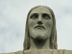
A symbol of Brazilian Christianity, the statue has become an icon for Rio de Janeiro and Brazil.[2] It is made of reinforced concrete and soapstone, and was constructed between 1922 and 1931

The Pyramid at Chichén Itzá (before 800 A.D.) Yucatan Peninsula, MexicoThe chichen Itza once served as the political and economical center of Mayan civilization.The city housed master pieces like the like the temple of Chac Mool ,the hall of thousand pillars , the playing fields of the prisoners and the pyramid of the kukulkan which was the last Mayan temple.
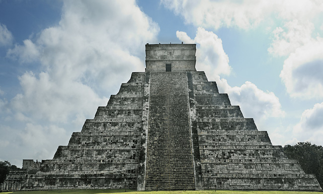
In its classic period, running about 250 BC through AD 850, the Mayan civilization ranged from Mexico through Guatemala, Belize, Honduras and El Salvador.During the first millennium AD, the Mayans reached levels of civilization rivalling those of ancient Egypt, Greece and RomeThey were superb astronomers, architect/builders, athletes and mathematicians.But for some unfathomable reason they never discovered the wheel.
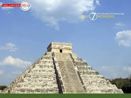
In times when Chichen Itza flourished as a city, the Mayas formed a highly sophisticated society. Their elite did remarkable work in astronomy, mathematics, engineering and architecture, while the rest provided manpower to execute the plans.Largest of Mayan cities, Chichen Itza was started around 400 A.D., abandoned and returned to several times before the Toltecs arrived in 987 A.D.The aggressive Toltecs conquered the Itzas, introduced them to the practice of sacrifice and with their labor rebuilt the city as a religious centre.
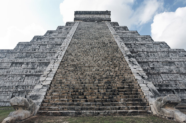
Everyone moved out by the thirteenth century, so when the Spaniards came in the 1500s they found crumbling buildings being devoured by the greedy jungle.A New York lawyer rediscovered them in 1842, following which an influx of amateur archeologists destroyed some.Real restoration and reconstruction by the Carnegie Institute and Mexican government was begun in 1922, and continu human ed for 20 years.
The names of seven wonders of the world are:
